|
About those satellites...
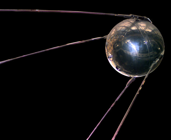 A NASA replica of Sputnik 1 in the NASA Air and Space Museum; the original was launched on 4 October 1957 (5 October Pole time). The signal was heard by Paul Siple and his crew at Pole. Sputnik 1 broadcast its steady beep for 3 weeks before its battery died; it would continue to orbit silently until 4 January 1958 (Wikipedia).
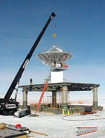
As for the satellites themselves, since they were old the orbits wobbled so the station could see them a few hours a day. MARISAT-F2 (Maritime Communications Satellite), GOES-3 (Geostationary Operational Environmental Satellite, as it was a NOAA weather satellite), and TDRS-1 combined [the links for individual satellites here are to Wikipedia articles] gave a window of almost 12 contiguous hours per day with an original theoretical 5 MBPS transfer speed, which has been upgrades several times over the years to more than 60 MBPS. Most of the increased bandwidth goes to data transfer. The oldest of these three, MARISAT-F2 was decommissioned in October 2008 after deterioration in its telecommand link (Antarctic Sun article). This cut the total window by two hours and the bandwidth by a bigger percentage. A year later in October 2009, the TDRS-1 satellite (or TDRSS-1, depending on the NASA contractor and acronym you As for the changing/shrinking constellation of NASA TDRSS satellites--they have been TDRS F3, TDRS F4 (until it was retired in 2011), TDRS F5 (scheduled for retirement in December 2014--1 December 2014 USAP service announcement), and TDRS F6--a second antenna terminal, the 4-meter SPTR-2 (South Pole TDRS Relay) link was completed during the 2008-09 summer (right, a construction photo from Dave Smith; here are more), and here is an April 2009 USAP page with a link to an Antarctic Sun article--lots more info. These satellites often are available for much shorter periods on an ever-changing schedule, and at a greater expense to NSF. They provide a 5 Mbps IP data link, and a separate 150 Mbps one-way (northbound) link for bulk science data. Not all of the "above-the-horizon" time (what typically appeared on the old scroll satellite availability page) is actually available to USAP--the program aims for about 4 hours per day, and at one time this created a complex daily scheduling job for a friend in Denver. Here's the USAP information page about the TDRSS systems. During the 2009-10 summer some field tests were conducted using the Intelsat/Paradigm/Astrium-operated Skynet-4C British military satellite, which was slowly increasing in visibility at Pole. In October 2009 a sole-source contract was awarded to Intelsat for use of this satellite. Here is the award announcement, an archived 2010 case study announcement from Intelsat, and a more detailed archived March 2010 Intelsat news release on the initial testing (interestingly, these satellites use the Oakhanger ground station southeast of London in the UK--while working for Ford Aerospace I visited that station in 1980 as part of a US Air Force satellite contract I was then involved with...and Philco-Ford,
In addition to the larger geosynchronous satellites there is, of course, Iridium, which is always available for official/emergency phone calls. Additionally there is a data link consisting of 12 Iridium phones, each capable of a 2400 bps data link, which are multiplexed to produce a 28 kbps data link. For a time USAP used this for 24/7 email (for small emails <50k or so), but that has been discontinued. More recently, the IceCube project has implemented other mail/text systems using Iridium. Here is USAP's information page about the Iridium system. Other resources linked here: -the recently upgraded and enhanced USAP satellite information pages with links to the weekly satellite schedule PDF file (the link changes each week) as well as this 2017 systems architecture diagram and overall system FAQs. -a July 2011 PDF presentation by Gary Ferentchak titled "Data Retrieval from the Frozen Continent". -a brief NSF 2006 Powerpoint presentation by Erick Chiang and Pat Smith, titled "Data Communications Supporting Astronomy/Astrophysics at South Pole Station" which addresses the conditions and future plans at that point in time. -a May 1995 report by Bob Loewenstein, Bill Smythe, and Brent Jones, Science Requirements for South Pole Station Computing and Communications. Some interesting facts, figures, and historical background. 1 GB/day of data transmission--hmmm, where would that leave IceCube? Links and data updated 25 July 2023 but is there newer info that I'm missing? |
