Phoenix Airfield Rising
|
UPDATE #2! The Phoenix Airfield..and its first PASSENGER aircraft on 27 January 2017. Development of Pegasus took place in the early 1990s, near a site which had formerly been used/known as Outer Williams Field. Construction started in 1991-92, the following year an initial 6,000-foot runway was used by wheeled C-130's, and in January 1994 it was certified for use by C-141 aircraft (early history and links). Initially the runway was only used at the end of the austral summer seasons and was then allowed to accumulate snow cover which would preserve it through much of the following summer season until it was reactivated. Although Pegasus was originally conceived as part of a "blue ice runway" survey, it actually came to be more properly known as a "white ice runway" as the base was not a permanent glacier, but rather a 100-foot-thick permanent sea ice shelf. The surface came to be maintained with a perhaps 5-inch layer of processed and leveled snow.
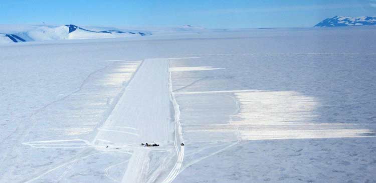
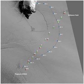
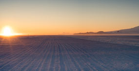
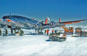
In subsequent seasons, the program continued the use of two airfield sites, with Williams Field inactive but maintained as a backup for ski-equipped aircraft. Meanwhile, several studies were underway evaluating future consolidations of air operations into a single airfield site location (references [1] and [2]). In 2012-13, a new problem arose. While Pegasus had originally been constructed in an area on the ice shelf, sheltered from mineral dust blowing from nearby Black Island...the 140-foot annual movement of the ice shelf moved the runway site into an area where, in recent years, storms would blow significant quantities of dark dirt and dust from the Black Island region onto the Pegasus runway and skiway as well as nearby roads. And there was less snow accumulation to compensate/ cover up the dirt. The black dust particles (up to at least 1/16 inch in diameter) caused severe melting resulting in closure of the wheeled airfield during much of the latter part of the 2012-13 season (February 2013 Antarctic Sun article "Bumpy Ride") as well as in subsequent seasons (January 2014 Antarctic Sun article "No Fly Zone"). Weather conditions were milder in 2014-15, meaning there was relatively little melt. But the results of the second airfield consolidation study (reference [2]) included two site recommendations--the single site runway should either be in the vicinity of the existing Pegasus runway, or near milepost 10 along the access road to Pegasus. More detailed site surveys, core sampling, and airspace analysis in 2014 resulted on the final site selection...which turned out to be near mile 11 of the current Pegasus road, as depicted at left. The satellite imagery at above right shows the core sample locations relative to the Pegasus road. After site selection, NSF's initial environmental review (reference [4]) (which contains significant technical detail) was completed in August 2015, and the final design proceeded--resulting in the first compacted snow runway of its kind in the world which can support C-17 operations. Keep in mind that the shelf ice is moving about 100 feet per year in a southwesterly direction, so the current location of Pegasus had moved about 1/2 mile since its establishment, into an area of less snow accumulation (and presumably more into the area affected by the Black Island dust-affected area. The new location currently sees 9-12 inches more snow accumulation per year than the current site, Fleet Operations conducted an intense development effort for what was then termed the "Alpha Runway" throughout the 2015-16 summer season. And then...on 7 April 2016...NSF officially announced that the new runway would be completed in time for operational testing and flight support during the 2016-17 season. And the announcement also mentioned that the new runway would be known as Phoenix Airfield. This continues the tradition of naming these prepared ice all-season runways for mythical winged creatures...or perhaps for the two C-121J Constellation wheeled aircraft that the one-time Navy VX-6 squadron had named for these mythical winged creatures (Joe Hawkins' page about these aircraft). The Pegasus had crashed while landing on 8 October 1970 on its first flight of the season (only slight injuries) and was later towed to its current location near what was then Outer Williams Field. But the other Constellation, the Phoenix (seen at right) survived...it was retired by the squadron after the 1970-71 season...and was eventually scrapped. Below...another photo from 14 April, looking NNW at sunset along the under-construction Phoenix Airfield. Ross It would take the efforts of six people over 15 months to create the completed project, resulting in this...
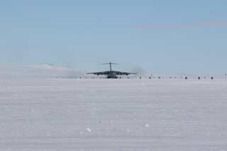
Island is at left; in the distance, a significant Fata Morgana distortion/mirage of the Dellbridge Islands (BH) (USAP photo library link to original).  UPDATE! The first C-17 flight landed on the new Phoenix runway on 15 November 2016. Here's the Antarctic Sun article! And see the photos below! | ||||
|
Actually things weren't quite as simple as the above photos might indicate--this was a certification operation. So this aircraft initially landed at Pegasus where passengers and cargo were unloaded. It then took off, flew to Phoenix for the first landing, taxied around the parking apron, took off again, landed again at Phoenix, and parked for 30 minutes before taking off and returning to Pegasus. UPDATE #2! NSF's (reference [5]) revised environmental concurrence was issued on 26 January 2017...and the first official C-17 carrying passengers landed at Phoenix the next day McM time-27 January. Below, a photo of it just after touchdown on 27 January 2017 (JG). Postscripts...the two C-17 flights previous to the November certification were the aircraft carrying U.S. Secretary of State John Kerry to and from McMurdo...they both landed at the Pegasus airfield. And Pegasus would see one more flight...five days after the certification, the same C-17 pictured in the certification photos would make one last Pegasus landing. That C-17 flight was the last scheduled C-17 flight until the beginning of February, although there were several scheduled flights by New Zealand and South Africa wheeled Hercules aircraft scheduled before the currently announced 3 December final closing date for Pegasus. The first Phoenix landings (well, touch and goes, actually) by an LC-130 on wheels occurred on 30 January 2017.  Yes, there's a blue sign with the official airfield name. The ICAO code is NZFX. And yes, this is the crew that created this unique runway (JG). References and credits: [1] McMurdo Consolidated Airfields Study, Robert B. Haehnel, Kevin Bjella, Margaret A. Knuth, and Lynette Barna. CRREL technical report 13-5, January 2013. [2] Design and Implementation of a Consolidated Airfield at McMurdo, Antarctica, Robert Haehnel, Margaret A. Knuth, Terry Melendy, Christopher Hiemstra, and Robert Davis. CRREL report 14-22, September 2014. [3] A Snow Runway for Supporting Wheeled Aircraft, Robert B. Haehnel, George L. Blaisdell, Terry Melendy, Sally Shoop, and Zoe Courville. CRREL report 19-4, May 2019. This report includes extremely detailed design and construction information. [4] "ENVIRONMENTAL DOCUMENT CONCURRENCE; Construct Alpha Airfield Facility at McMurdo Station, Antarctica", Susanne LaFratta, Section Head, Polar Environment, Safety, and Health, NSF, 21 August 2015 (MCST1601.IEE). [5] "ENVIRONMENTAL DOCUMENT CONCURRENCE; Establishing Phoenix Airfield Town Site and Closing Pegasus Airfield at McMurdo Station, Antarctica", Nature McGinn for Susanne LaFratta, Section Head, Polar Environment, Safety, and Health, NSF, 26 January 2017 (MCST1601.IEE.AM1). JG is Jack Green who has spent many many hours working to create and ready the new airfield; he also shared with me some of the technical details. The two April 2015 photos of the Phoenix runway are by NSF McMurdo station manager, friend, and fellow 2005 Pole winterover Bill Henriksen (BH). The Phoenix aircraft photo is by the late Fred Mayeda (FM) who wintered at Pole in 1959; his photos have been shared with me by his family. | ||||
