The Pole of Inaccessibility (POI)
...perhaps more properly named the Pole of Relative Inaccessibility these days
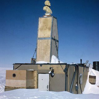
 The bust of Lenin atop the building chimney, as seen in 1965 (1) (click to see references at bottom). The 18-man tractor team, part of the Third Soviet Antarctic Expedition (SAE), arrived on 14 December 1958 from Sovetskaya and set up the Pole of Inaccessibility Station at 82°06'S-54°58'E, the point in Antarctica furthest from any ocean. The team had brought that sled-mounted 4-man 260-square foot hut, which was equipped with an electric furnace as well as a backup oil stove. There was a 13 kw generator and a radio shack, and the station was initially provisioned with a 6-month food and fuel supply. A bust of Lenin was erected atop the chimney on the roof of the hut, originally looking toward Moscow as seen here. After a brief ceremony they raised the USSR flag, shouted "Hurrah," and fired rockets into the air. | |
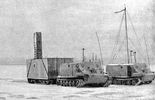 Some of the original traverse vehicles, one of which is pulling the sled-mounted hut with that chimney, not yet boxed in with plywood (2). |
|
 Looking southeast with the main hut in the center background. At left is one of those 35-ton Kharkovchanka ("snow tractor") vehicles, two of which would show up at Pole in 1959-60 (4). |
 The 1958 site plan (4) (here is another version with an English legend). Also see the later site plan below. |
|
Other facilities included a 4000x100-foot skiway, two 65-foot radio antenna towers and a set of meteorological instruments. In addition to met observations, the science included seismic, gravity, and magnetometer observations. Snow sampling included a 165-foot borehole into the firn. The station leader during this period was meteorologist V. K. Babarykin. An aircraft landed on the 18th and picked up four of the expedition members. The scientific observations continued until the rest of the team left on the 26th...as the station was deemed too remote for permanent use. The next visit to this station was a return trip by the Russians in January 1964 as part of the Ninth Soviet Antarctic Expedition. This was a 16-man venture out of Vostok which used two large Kharkovchanka tractors (of the type used on the 1959-60 traverse to Pole) and another tractor with geodetic equipment. It also had air support. The first part of this traverse reached the POI on 1 February, the remainder arrived on the fourth. They took geodetic and seismic readings en route, and on 6 February they continued on into Queen Maud Land for another 6 weeks of survey work. The next visitors were the nine members of the first leg of the multi-year and multinational USARP South Pole-Queen Maud Land Traverse (QMLT), which had departed Pole on 5 December 1964 in three Sno-Cats. After traveling a 900-mile zigzag course, they reached the POI on 28 January. This glaciological and geophysical traverse was led by Dick (Richard) Cameron of The Ohio State University; the leader of the geophysical studies was the late Charlie (Charles) Bentley of the University of Wisconsin. When the team arrived, they were greeted not only by that plastic bust of Lenin, but also by a note left by the Russians describing the station and its supplies, as well as cigarettes and matches. These had been left by the Russian traverse of the previous season, who knew of the proposed American traverse (in return, the Americans made some measurements which had been requested by the Russians. The American team stayed at the site until 2 February, when they were picked up by an LC-130 and flown to McMurdo. Their vehicles were left behind...to be used the following season for the second leg of the traverse. This 11-man team was flown to the POI on 22 November and departed on the next phase of their traverse on 15 December. Here's a route map of the first two years of the South Pole-Queen Maud Land Traverse (5) and another photo of the POI from November 1965. 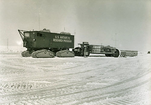 Here's a photo of the traverse leaving Pole on 4 December 1964 (U.S. Navy photo shared by Mike Davis; the Picasa link is no longer online). Below, more traverse photos by members of the traverse parties: | |
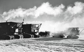 The The traverse prime movers--two model 843 Tucker Sno-Cats and one model 742, which was equipped with a drilling rig. These pulled two Rolligon transporters (trailers with special tires carrying fuel) and four 1-ton sleds (photo by Charles Bentley) (2). |
|
 Looking west at a theodolite shot being taken east of the main hut; the meteorological shelter and anemometer tower are in the background. The subject of this sighting is a Playboy centerfold (!) (January photo from Dick Cameron) (6). |
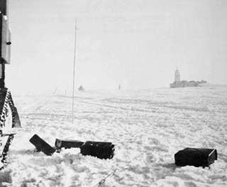 Looking west from next to one of the vehicles. The hut is at left, and the met instrument shelter is in the center background. The pole in the foreground may be the flagpole seen above behind the snow tractor (January photo by Edgar Picciotto) (7). |
 Supposedly, this is the hut interior, as seen by the team preparing to depart on leg 2 of the South Pole-Queen Maud Land Traverse in 1965-66 (photo attributed to Olav Orheim) (8). |
 Here's another presumed interior view of the hut (9). But some of the items in these photos appear much newer than 1958 or even 1965, and Olav told me that the QMLT folks did not heat the hut interior. |
|
I must say that I discussed the above two photos with Olav Orheim; he said they were not his...perhaps they are from one of the Soviets' Oasis stations. But I left them on this page because they sort of represent what the interior might look like.
The most interesting mystery about this place involves that bust of Lenin: | |
|
Olav Orheim's photo at the top of this page (reproduced above left) (1) shows Lenin looking west (assuming that the Russian site plans are correct--after all, they drove here). But all of the other photos on this page, including the one above right (also by Orheim in 1965) (2) 10 shows him facing north. The generally accepted story is that the Russians oriented the bust to face Moscow (which is on longitude 37º37'E, almost directly north of the POI). But the traverse members reportedly rotated the bust to face Washington DC. The Russians would return for the last time (so far as I am aware) in 1966-67 (the 12th Soviet Antarctic Expedition) as part of an extended traverse from Molodezhnaya Station to the POI, to Plateau Station, to Junction Point (?), and on to Novolazarevskaya Station. The traverse included extensive geodetic, seismic, and magnetic observations. They reached the POI on 23 February. They were on station for less than 2 days, departing on the 25th, but during this visit the station was mapped (at right (2); here is a larger version with index). They were at Plateau for less than 24 hours on 3-4 March, and arrived at Novo on 26 March.
(1) Olav Orheim photo from November or December 1965, available from this 3 December 2011 blog post from the Norwegian Polar Institute. Olav was a member of the 1965-66 second leg of the South Pole-Queen Maud Land Traverse which originated at the POI; this blog was documentation of a Norwegian ski traverse retracing Amundsen's route from the Bay of Whales to Pole, part of the Amundsen centennial commemoration. (2) Images from this historical page prepared by Tom Neumann as part of the Norwegian-American Scientific Traverse of East Antarctica (archive) website. The traverse was a 2-season project (2007-08 and 2008-09) from the Norwegian Troll station near the coast, to Pole, with a return the following year. Tom collected this information while at Troll in November 2007; I was in touch with him at that time and provided him some of the background information he used. The 1958 image of a tractor pulling the hut, and the 1967 site plan with translation, are from a book (in Russian) by N. Gvozdetsky; they were provided to Tom by Henry Cookson of Team N2i. (3) This image is attributed to Scientific Stations in Antarctica, 1882-1963 (item 4 below) but it does not appear in my English translation copy. My source for it is this thread on the polarpost.ru message board (in Russian); the image was posted by Alexander Andreev in 2008. (4) Images from Scientific Stations in Antarctica, 1882-1963 by L. I. Dubrovin and V. N. Petrov, 1967. NSF contracted an English translation of the original Russian work which was published in 1971. It was formerly available from the NSIDC...I have it here. (5) From "The South Pole-Queen Maud Land Traverse II, 1965-1966" by Edgar Picciotto, Antarctic Journal, July-August 1966 (article link). (6) "To the Interior of the Ice Sheet, QMLT 1964-65," a presentation by Dick Cameron about the Queen Maud Land Traverse, in "Antarctic Exploration Parallels for Future Human Planetary Exploration: The Role and Utility of Long Range, Long Duration Traverses,, a NASA Conference Publication for the Antarctic Exploration Parallels for Future Human Planetary Exploration Workshop, Houston, Texas, 4-5 August 2009. Published in 2012 (complete conference report--38mb). Note that the photo captions are listed before the photos. (7) Glaciology of the Queen Maud Land Traverse, 1964-1965; South Pole-Pole of Relative Inaccessibility by R. L. Cameron et al, Institute of Polar Studies, The Ohio State University, April, 1968 (abstract and link). (8) This photo is attributed to Olav Orheim and is publicly available on this io9.com page documenting abandoned Antarctic stations. Per Olav, it is NOT his photo from the POI. (9) This photo appears along with the previous one by Olav Orheim in this 8 April 2013 Mail Online (London) photo essay on abandoned Antarctic stations. Again, Olav Orheim told me these were not his photos. Henry Cookson's photo of the POI in 2007 (Wikipedia). (10) This photo appears with the 1 January 2008 news article (archive site) by the Norwegian-US Scientific Traverse noting their arrival at the POI. (11) Soviet Geographical Explorations and Discoveries by N. A. Gvozdetsky. English translation by Anatoly Bratov, 1974. The section of the book which describes the Third SAE and the setup of the POI station can be found here. (12) Geomagnetic Report - South Pole-Queen Maud Land Traverse I, 1964-65 by Norman Peddie, U.S. Department of Commerce, Coast and Geodetic Survey (available here). | |


