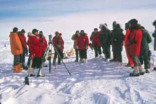
 Once a year the USGS folks would "move the Pole" (right, photo by Tadashi Yogi)...actually the geographical South Pole stays at the same spot on the surface of the globe (at least for our purposes. There are short and long-term "wobbles" that are not relevant to this exercise). The icecap on which we and the station are standing moves approximately 33 feet or 10 meters per year in a direction between 37° and 40° west of grid north. The movement is slightly erratic from year to year for some reason, perhaps because we have gotten better at measuring it! Anyway the station site is moving slowly in the direction of South Georgia in the South Atlantic Ocean. Once a year the USGS folks would "move the Pole" (right, photo by Tadashi Yogi)...actually the geographical South Pole stays at the same spot on the surface of the globe (at least for our purposes. There are short and long-term "wobbles" that are not relevant to this exercise). The icecap on which we and the station are standing moves approximately 33 feet or 10 meters per year in a direction between 37° and 40° west of grid north. The movement is slightly erratic from year to year for some reason, perhaps because we have gotten better at measuring it! Anyway the station site is moving slowly in the direction of South Georgia in the South Atlantic Ocean.
In our era the movement was calculated based by the satellite tracking operation-- the exact geographical position of the sattrack antenna was computed from the tracking data  from many low-orbiting satellites, much as a simple GPS receiver does today. Actually, the satellite tracking project was an important precursor to development of the GPS system, so I really can say we were using a GPS from many low-orbiting satellites, much as a simple GPS receiver does today. Actually, the satellite tracking project was an important precursor to development of the GPS system, so I really can say we were using a GPS .
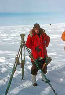
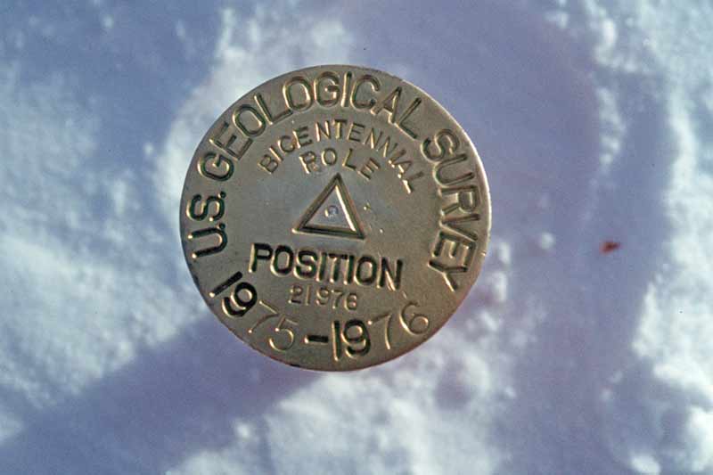
The actual "relocation of the Pole" was really a ceremonial exercise involving turning an angle from the previous year's location, and measuring off the proper distance based on the movement of the sattrack antenna. While our USGS winterovers Jim Fletcher and Ken Barker had done all of the preliminary dirty work, the actual event was performed by Robert H. Lyddan (right) who was head of the topographic division for USGS. The Pole locations had previously been marked with stakes or copper pipes, but in honor of the Bicentennial and Mr. Lyddan's visit, the Pole survey marker, shown above, was created. Given the dates on the marker, I'm thinking that original plans were for it to be installed in 1975-76, but the LC-130 crashes at Dome C drastically curtailed the 1975-76 activities. Oh, this marker disappeared two days later, never to be seen again. Some time later the idea for bench marks became an annual event, and nowadays, the markers and stakes are artistic creations by the machinist on station--sometimes specially machined from a single piece of material 12' long...such as the 1994 marker (here's an archived description of the Boxing Day 1993 marker ceremony from NASA QUEST). It was much too large to fit in an orange bag, and very difficult to remove for a souvenir...but it was stolen anyway...as was the 2003 marker which was smaller. .
The actual "relocation of the Pole" was really a ceremonial exercise involving turning an angle from the previous year's location, and measuring off the proper distance based on the movement of the sattrack antenna. While our USGS winterovers Jim Fletcher and Ken Barker had done all of the preliminary dirty work, the actual event was performed by Robert H. Lyddan (right) who was head of the topographic division for USGS. The Pole locations had previously been marked with stakes or copper pipes, but in honor of the Bicentennial and Mr. Lyddan's visit, the Pole survey marker, shown above, was created. Given the dates on the marker, I'm thinking that original plans were for it to be installed in 1975-76, but the LC-130 crashes at Dome C drastically curtailed the 1975-76 activities. Oh, this marker disappeared two days later, never to be seen again. Some time later the idea for bench marks became an annual event, and nowadays, the markers and stakes are artistic creations by the machinist on station--sometimes specially machined from a single piece of material 12' long...such as the 1994 marker (here's an archived description of the Boxing Day 1993 marker ceremony from NASA QUEST). It was much too large to fit in an orange bag, and very difficult to remove for a souvenir...but it was stolen anyway...as was the 2003 marker which was smaller.
Oh yes...in the upper left photo of us watching this event, you will notice an aircraft circling to land. This was one of the four aircraft that ended up parked on the taxiway overnight due to bad weather at McM--three VXE-6 LC-130's and a BAS Twin Otter. Mr. Lyddan and his party of DV's got to stay overnight with us as well. While I was taking the picture I was already worrying about what to do with all of the overnight visitors...turns out our population was 106, then a Pole record.
For too much more information about the geographic pole, and an essay or two on how it is located these days, here is an archived NASA Quest page about moving the Pole marker on Boxing Day, 1993, an old archived CARA page on the subject, and a more recent AAD (Australian program) page about the various Poles.
|


